Agrico Chemical
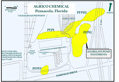
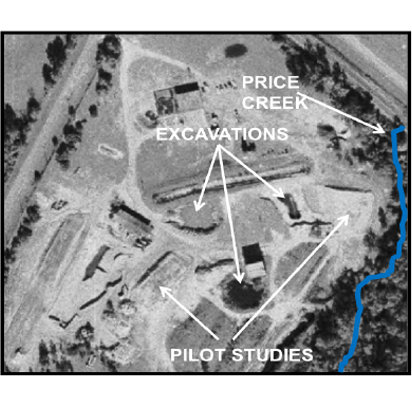
The Agrico Chemical site is a 35-acre Superfund site in Pensacola, Florida. The plant began operation in 1889 and produced sulfuric acid, superphosphate, and monosodium phosphate. When the plant closed in 1975, all equipment and buildings were removed. To initiate a Remedial Investigation/Feasibility Study (RI/FS) under EPA oversight, aerial photographs and interviews were used to identify and map the aggregate footprint of former unlined hazardous waste water discharge ponds. The results were used to develop assessment plans and remedial strategies for the pond sludge.
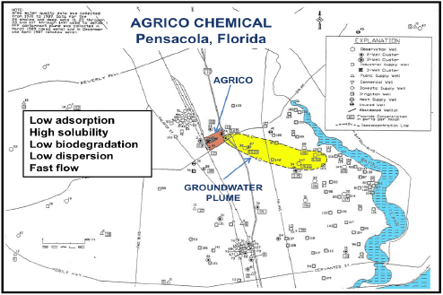
Earth Systems geologists researched the hydrogeology of the underlying Sand and Gravel aquifer to most efficiently define a 1.3-mile long inorganic contaminant plume from the AGRICO pond sludge. The impacted portion of the aquifer as a whole is heterogeneous, but layered. Groundwater flow is mostly lateral within the most permeable layers to the closest major surface water body. The low pH of the source material increased contaminant solubility and decreased contaminant adsorption to soil. Natural degradation of inorganics by bacteria is limited. Therefore, contaminant movement was mostly controlled by advection. Groundwater flow in the Sand and Gravel is relatively fast and there is relatively low hydrodynamic dispersion, all of which was predicted to produce a long and relatively narrow plume. This accurate prediction allowed plume definition with fewer wells, which saved time and money.
Veritech Drycleaning
The Veritech site in Pompano Beach, Florida is a former commercial drycleaning facility impacted primarily with Trichloroethene (TCE) and degradation compounds—mostly Vinyl Chloride (VC). Earth Systems’ historical research improved development of remedial alternatives and hastened site cleanup. Previous consultant’s remediation attempts included pump and treat, limited source removal (an abandoned septic tank), bioremediation, and free product recovery. Free product was no longer detected, but source area concentrations of TCE and VC remained relatively unchanged. Earth Systems presumed DNAPL TCE remained onsite because it was detected at high dissolved concentrations. Earth Systems reviewed historical TCE distribution, groundwater flow direction, and lithology to identify logical DNAPL locations. Building records were then reviewed for potential sources in those locations, and an abandoned septic tank was identified. The subsequent remedial action included removal of the septic tank and 287 tons of associated hazardous soil and sludge and the installation of seven injection/air sparge (AS) wells and five vapor extraction (VE) wells. Based on site lithology, Earth Systems then worked closely with Broward County to decrease injection well spacing for better delivery of bio-enhancing reagent. Within six months TCE source area concentrations decreased from an average of 19,000 µg/L to 4.8 µg/L, and Vinyl Chloride decreased from 16,000 µg/L to 36 µg/L.
Marion County Charcoal Plant
At an 11-acre former charcoal manufacturing site in Marion County, Florida, Earth Systems defined free product (weathered diesel fuel) and a plume mostly comprised of naphthalenes. The discharge was reportedly from a UST. The shallow saturated zone beneath the site is not an aquifer, composed of low permeability clay and sandy clay. Naphthalenes have a high retardation factor and the saturated sediments have a high organic content. Therefore, contaminant movement was dominated by chemical and physical dispersion. As expected, the plume shape was almost circular and natural processes were stabilizing the plume. However, the plume map showed a contaminant distribution much farther downgradient and especially upgradient from the UST than would be expected if produced by advection and dispersion.
Although evidence (staining or high TRPH concentrations) did not remain in the thin sandy unsaturated soils above the plume, follow-up interviews led to the discovery of multiple surface spills from various fueling locations (including upgradient of the UST) approximately 25 years in the past. The fuel may have traveled from the different spill locations along sloped paving, unpaved swales, or piping trenches farther and in a different direction than if carried by groundwater. These assessment insights shortened the time required to complete cleanup.
Phase I and II ESAs / Brownfields
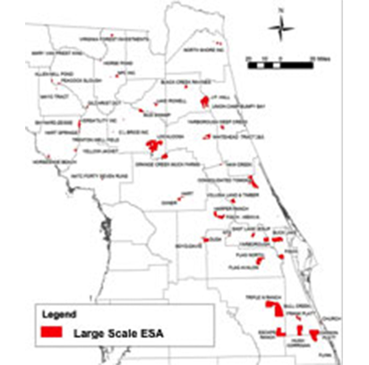
Earth Systems regularly performs Phase I and II ESAs for real estate transactions and Brownfields redevelopment. ESAs are performed in accordance with applicable current ASTM and AAI requirements and tailored to the requirements of individual clients. The Earth Systems team has 28 years of experience specializing in contamination assessment and remediation and has completed more than 450 Phase I ESAs.